GPS Metadata
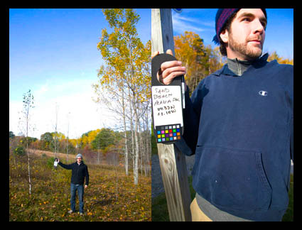
The digital r/evolution brings new habits. In my workshops we take GPS coordinates and location name (with my iPhone) and post them on a bulletin (along with a white balance target). Participants photograph the data at the beginning of each session/location. That way everyone has two pieces of useful information in one shot. It can be used for folder and file names and/or metadata.
I’ve been waiting to incorporate GPS data in my workflow until GPS is built right into my camera, but the inevitable hasn’t come as fast as I hoped for. If my cell phone has it built in, why doesn’t my 1DS Mark III? It’s probably time to buy a GPS attachment. Or should I go with a stand alone GPS unit that has a touch more accuracy and later sync the tracks? Either way, the message is just get started. The data’s too useful right now. And the longer I wait, the longer it will take to update all my old files.
Do you use GPS coordinates? What do you use? Comment here.
Check out my workshops here.
Frédéric
20.10.2008 at 02:41Hello,
I recently view a little GPS unit you let in your bag. Then at the end of your outdoor shooting sesssion you plug it into your computer and a software will add on photos in a directory, the GPS infos. Only with time syncronisation ! So easy.
Here is that Sony tool review on DPreview
http://www.dpreview.com/news/0608/06080202sonygpscs1.asp
Hope you get this information right here !
Fred
Eric Scouten
20.10.2008 at 03:04Hi JP, good to hear from you again …
I geocode pretty much 100% of my photos, and have been doing this for several years now. (Maybe I’m too obsessive about it?)
I have an iPhone 3G and I briefly considered using it as my GPS photography companion, but there are a couple of major problems with doing so: (1) If you install any of the apps that create a GPS track log, you’ll run the battery into the ground really quickly. (2) The approach you’ve described [taking a photo and using its coordinates] often leads to incorrect information. Apparently the GPS unit doesn’t have time to lock on to a valid location for some time after you turn it on. I’ve seen photos misplaced by as much as a mile if I turn on the camera and shoot quickly. 🙁
So I’m back to my dedicated (Garmin) handheld GPS unit. Much easier on the batteries and more accurate results.
I wrote an article on geocoding with Lightroom last year. Pretty much everything I said then (for Lightroom 1.3) remains current today (for Lightroom 2.x).
http://blogs.adobe.com/lightroomjournal/2007/11/geocoding_your_photos_with_lig.html
Einar Erlendsson
20.10.2008 at 06:03I agree with you JP on that I have been waiting for high end cameras with GPS built in. But there are several not expensive solutions available if you care to walk around with an GPS while you are shooting.
http://lightroom-news.com/2007/03/23/gps-metadata-in-lightroom-and-google-maps/
http://www.cameratown.com/news/news.cfm/hurl/id%7C3758
http://www.computer-darkroom.com/lr_11/lr-11-gps.htm
Chris
20.10.2008 at 08:40I use a stand alone unit called “Photo Trackr” It seems to work fairly well. You sync the time of the gps with your camera time and then when your back at your computer I use their software to match up the time stamps and it embeds the data in the photo’s then I import them in to lightroom and it’s done..
Greg Barnett
20.10.2008 at 11:16Hi JP,
Sensitivity and the ability to pull in good signal under less than ideal conditions (heavy forest cover, canyons, etc.) is what currently limits many of the cheaper devices. Since you already know how much of a stickler I am for accuracy… I’m of the camp that advocates for a higher quality stand-alone GPS unit like the Garmin 60CSx. Besides the accuracy and sensitivity, it allows you to record a running tracklog (in the GPX format) to an internal SD card. So at the end of the day you only have a single tracklog even if you turned the unit on and off several times. Then using something like ImageIngester Pro, you can sync up the images and have the coordinates written either to XMP sidecars or directly in to DNG’s. Hopefully one of these days, Adobe will get tired of many of us pestering them for the ability to tag directly in Lightroom and add it in as an option during import.
I’ve been tagging (via GPS) every image I shoot for the last couple of years. Now I’m going back to older images and manually tagging them with HoudahGeo and Google Earth.
Greg
Greg Barnett
20.10.2008 at 11:34Forgot to mention a new plug-in for Lightroom that GPS users might be interested in:
http://regex.info/blog/2008-10-18/967
It allows you do do proximity searches for tagged images in your catalog.
G.
Mike Nelson Pedde
20.10.2008 at 13:28Jeff Friedl has a ‘GPS proximity’ plugin for Lightroom, here:
http://regex.info/blog/2008-10-18/967
Mike.